Book I · The Republic in Italy
Infographic · I-G04
ROADS AS CONQUEST: The Arterial Consolidation of Italy (334–264 BC)
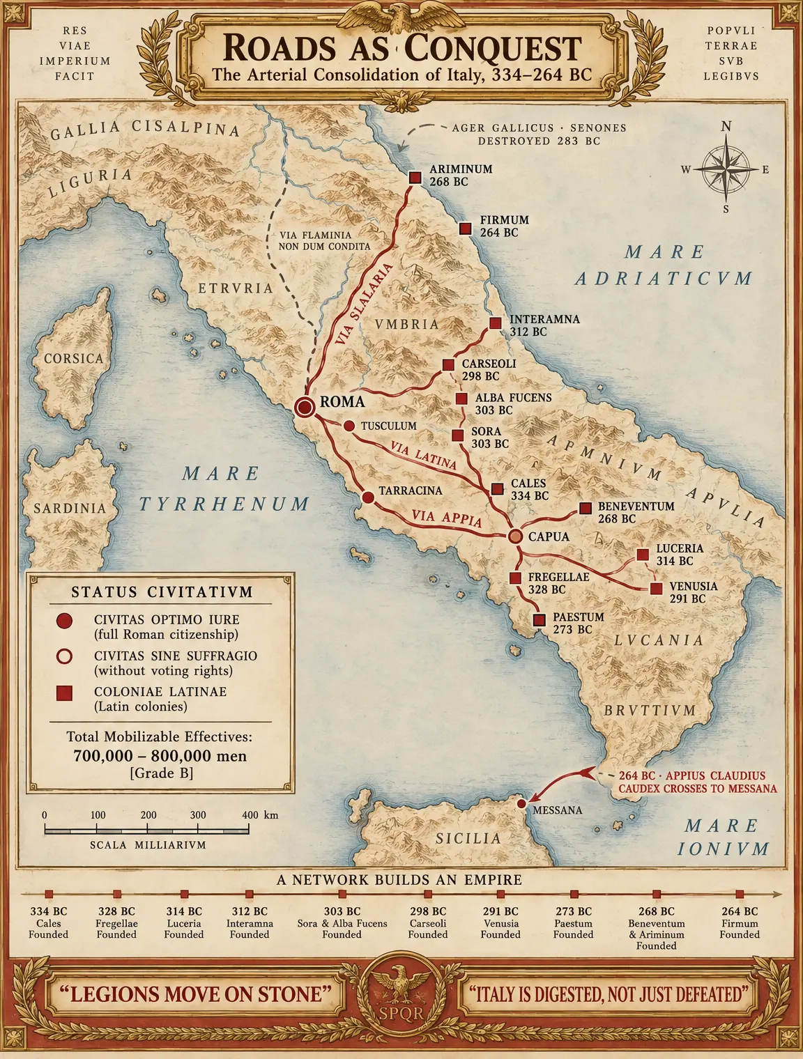
Between 334 and 264 BC, the Roman Republic bound Italy not merely through victorious campaigning, but through an irreversible infrastructure of paved consular arteries and fortified Latin colonies that permanently digested annexed territory.
DESIGN BRIEF: ROADS AS CONQUEST (334–264 BC)
1. Executive Purpose & Thesis
This technical infographic visualizes the military and demographic consolidation of peninsular Italy between the Latin Settlement and the outbreak of the First Punic War. Based on Book I of IMPERIUM ROMANUM, it demonstrates the dual-engine technology of Roman conquest: arterial military roads that permitted rapid consular redeployment, and fortified colonial nodes planted at choke points to permanently hold annexed territory.
Core thesis: Victory in battle opened country, but roads and colonies digested it. While enemies fielded armies for a season, Rome bound the terrain in stone, turning conquered territory into recruiting grounds for the next campaign.
2. Layout & Compositional Architecture
- Aspect Ratio: 3:4 vertical sheet, reflecting the north-south axis of peninsular Italy.
- Framing: Formal double-line border in terracotta (
#A85638) with gold corner palmettes (#B89954). - Ground: Aged vellum / archival cream (
#F4EBD5) with subtle sepia hachured relief indicating the Apennine spine. - Division of the Sheet:
- Header (Top 8%): Centered monumental gold titling cartouche flanked by the civic seal of the Republic.
- Central Geographic Field (Middle 72%): Peninsular map from the Po Valley frontier (Ariminum) south to the Strait of Messana.
- Left Flank Data Panel (Integrated into Tyrrhenian Sea area): Modular analytical text blocks detailing colonial classifications, juridical statuses, and demographic statistics.
- Bottom Infrastructure Timeline (Bottom 12%): Chronological horizontal band (334–264 BC) showing the synchronization of road building and colony foundations against major military crises.
- Lower Footer (Bottom 8%): Epigraphic twin cartouche with the operational motto.
3. Map Features, Arteries & Colony Nodes
The Arterial Network (Drawn in Roman Crimson #8B1A1A)
- VIA APPIA (Begun 312 BC by Censor Appius Claudius Caecus):
- Primary artery: Thick crimson stroke from ROMA south through the Pontine corridor to TARRACINA, swinging through the Formiae coastal gate to CAPUA (312 BC). Extended east through the Caudine pass to BENEVENTUM (268 BC) and plotted toward the Apulian plain.
- VIA LATINA:
- Inland corridor: Crimson line running parallel along the Trerus and Liris valleys, threading between the Volscian hills and Apennines through CASINUM to CALES.
- VIA SALARIA:
- Historic salt route: Crimson artery striking northeast through the Sabine hill-country toward REATE and the Adriatic.
- Cartographic Note: A prominent annotation explicitly indicates that the VIA FLAMINIA does not yet exist in this period.
The Colonial Nodes (Point Symbols by Status)
- Solid Crimson Squares (
#8B1A1A) — COLONIAE LATINAE (Strategic Fortress Colonies):- CALES (334 BC) — Choke point commanding the entrance to northern Campania.
- FREGELLAE (328 BC) — Middle Liris crossing, the pivot of the Second Samnite War.
- LUCERIA (314 BC) — Apulian salient planted behind the Samnite rear.
- INTERAMNA (312 BC) — Liris valley consolidation block.
- SORA (303 BC) — Upper Liris river barrier.
- ALBA FUCENS (303 BC) & CARSEOLI (298 BC) — Central Apennine surveillance holds.
- VENUSIA (291 BC) — 20,000 colonists (tradition's count [BGrade B]); the mass demographic anchor on the Apulian frontier.
- COSA (273 BC) — Etruscan coastal fortress.
- PAESTUM (273 BC) — Southern Tyrrhenian anchor at former Posidonia.
- BENEVENTUM (268 BC) — Bastion in the Caudine country of Samnium.
- ARIMINUM (268 BC) — Northern watch-post on the Adriatic frontier against the Cisalpine Gauls.
- FIRMUM (264 BC) — Picene coast surveillance node.
- Crimson Discs (
#8B1A1A) — AGER ROMANUS (Citizen Land & Incorporations):- ROMA (Hub), TUSCULUM, ARICIA, LANUVIUM (Full citizenship / optimo iure [AGrade A/B]).
- CAPUA (Allied municipal hub with civitas sine suffragio 338 BC [BGrade B]).
- SABINI territory (Incorporated sine suffragio 290 BC; elevated to optimo iure 268 BC [AGrade A/B]).
- Iron-Grey Washes & Outlines:
- Highland Samnite cantons (Pentri, Caudini, Hirpini, Caraceni), Lucani, and Bruttii shown circumscribed and penetrated by the arterial lines.
4. Verbatim Text Elements
Cartouche & Title Block
- Primary Title:
ROADS AS CONQUEST - Subtitle:
The Arterial Consolidation of Italy, 334–264 BC - Attribution:
IMPERIUM ROMANUM · BOOK I: THE REPUBLIC IN ITALY
Analytical Side-Panels
- Panel 1: The Graduated Settlement (338–264 BC)
CIVITAS OPTIMO IURE: Full citizenship; complete political absorption (Latium, Sabinum 268 BC).CIVITAS SINE SUFFRAGIO: Obligation of service and Roman law without the franchise (Campania, Picenum).COLONIAE LATINAE: Mixed Roman-Latin garrisons holding strategic choke points; autonomous local magistracies.SOCII NAVALES & CIVITATES FOEDERATAE: Bound by bilateral treaty to supply troops or triremes upon demand.
- Panel 2: Mobilization Manpower Pool (264 BC)
Full Citizens (Cives): ~300,000 [BGrade B, the tradition's arithmetic]Citizens without Franchise (Sine Suffragio): ~150,000 [BGrade B]Allied Pool (Socii): ~500,000 [BGrade B]Total Mobilizable Effectives: 700,000–800,000 men [BGrade B]Ager Romanus: ~25,000 km² | Allied Hegemony: ~110,000 km²
Map Annotations
- At the northern Adriatic border:
AGER GALLICUS · SENONES DESTROYED 283 BC · ARIMINUM PLANTED 268 BC - Along the upper Tiber / Umbria:
VIA FLAMINIA NON DUM CONDITA (Not yet built) - Along the Liris corridor:
THE FORTRESS BELT: CALES · FREGELLAE · INTERAMNA - At the southern Tyrrhenian coast:
PAESTUM 273 BC · GREEK POSIDONIA SUBDUED - Across the Strait of Messana:
264 BC · APPIUS CLAUDIUS CAUDEX CROSSES TO MESSANA
Infrastructure Timeline (Bottom Rail)
334 BC: Cales Founded328 BC: Fregellae Founded321 BC: Disaster at Caudine Forks315 BC: Defeat at Lautulae314 BC: Luceria Planted312 BC: Via Appia Begun by Appius Claudius Caecus · Interamna Founded303 BC: Sora & Alba Fucens Founded295 BC: Victory at Sentinum291 BC: Venusia Founded (20,000 Colonists)275 BC: Victory at Beneventum273 BC: Paestum & Cosa Founded268 BC: Beneventum & Ariminum Founded · Sabine Full Citizenship264 BC: Firmum Founded · Crossing to Sicily
Twin Epigram (Footer Cartouche)
- Left Panel:
"LEGIONS MOVE ON STONE" - Right Panel:
"ITALY IS DIGESTED, NOT JUST DEFEATED"
5. Attestation Grading Summary
- Colony Foundation Dates & Locations: AGrade A (epigraphic records / Fasti Triumphales / archaeological remains of ashlar circuits).
- Via Appia Construction & Route: AGrade A/B (Livy 9.29, Diodorus 20, confirmed by archaeological pavement horizons).
- Demographic Totals & Manpower Figures: BGrade B ("the tradition's arithmetic" derived from retrospective annalistic census figures via Polybius 2.24 and Livy).
- Venusia Colonist Count (20,000): BGrade B (tradition's count; exceptionally large, reflecting frontier strategic urgency).
6. Palette Enforcement
- Background Ground:
#F4EBD5(Warm Cream / Vellum) - Arteries, Colonies & Roman Territory:
#8B1A1A(Roman Crimson) - Relief Shading & Territorial Accents:
#B5824A(Punic / Apennine Ochre) - Independent / Opposing Territories: Muted Iron-Grey (
#5A5A5A) - Titling & Cartouche Borders:
#B89954(Antique Gold) - Outer Enclosure & Frame:
#A85638(Terracotta)
Image prompt (3:4)
A masterwork military-cartographic infographic in the historical-atlas style of Putzger and Spruner, titled 'ROADS AS CONQUEST' with subtitle 'The Arterial Consolidation of Italy, 334–264 BC'. Vertical 3:4 aspect ratio. Hand-rendered aesthetic on an archival cream background (#F4EBD5) with subtle Apennine mountain relief in ochre (#B5824A) and sea coasts outlined in faint slate-blue. The entire composition is framed in a crisp terracotta (#A85638) border with gold (#B89954) corner brackets. In the upper center, an ornate gold titling cartouche displays: 'ROADS AS CONQUEST' and 'The Arterial Consolidation of Italy, 334–264 BC'. Across peninsular Italy, heavy crimson (#8B1A1A) arterial roads radiate from 'ROMA': the 'VIA APPIA' extending through 'TARRACINA' to 'CAPUA' (312 BC) and inland to 'BENEVENTUM' (268 BC); the 'VIA LATINA' running through the Liris valley; and the 'VIA SALARIA' reaching the northeast. A delicate annotation in Umbria reads 'VIA FLAMINIA NON DUM CONDITA'. Key Latin colonies are marked as solid crimson square fortress glyphs with dated serif labels: 'CALES 334 BC', 'FREGELLAE 328 BC', 'LUCERIA 314 BC', 'INTERAMNA 312 BC', 'SORA 303 BC', 'ALBA FUCENS 303 BC', 'CARSEOLI 298 BC', 'VENUSIA 291 BC', 'PAESTUM 273 BC', 'BENEVENTUM 268 BC', 'ARIMINUM 268 BC', and 'FIRMUM 264 BC'. Citizen hubs appear as crimson circles at 'ROMA', 'TUSCULUM', and 'CAPUA'. At the upper Adriatic coast, an annotation reads 'AGER GALLICUS · SENONES DESTROYED 283 BC'. At the southern tip across the strait, a crimson directional arrow reads '264 BC · APPIUS CLAUDIUS CAUDEX CROSSES TO MESSANA'. In the left Tyrrhenian field, a formal boxed legend explains the legal statuses: 'CIVITAS OPTIMO IURE', 'CIVITAS SINE SUFFRAGIO', and 'COLONIAE LATINAE', alongside manpower statistics: 'Total Mobilizable Effectives: 700,000–800,000 men [BGrade B]'. Running along the bottom of the sheet is a horizontal sepia timeline rail ticking the infrastructure dates from '334 BC: Cales Founded' to '264 BC: Firmum Founded'. Anchoring the bottom margin is a prominent twin cartouche in terracotta and gold bearing the exact words: '"LEGIONS MOVE ON STONE"' on the left and '"ITALY IS DIGESTED, NOT JUST DEFEATED"' on the right. Elegant, legible classical serif lettering throughout; pristine archaeological clarity.
I-G04 · generated by the Imperium factory studio (gemini-3.8-flash) from Book I under the House Preamble.