Book IV · The Wars of Mediterranean Hegemony
Infographic · IV-G04
THE DISMANTLEMENT MAP: THE HELLENISTIC SYSTEM, 200–146 BC
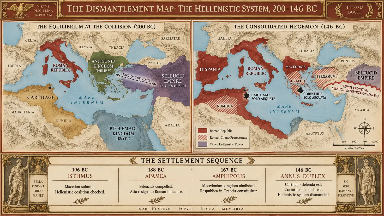
Hegemony without (much) annexation — until it wasn't: the fifty-four years that dismantled the Hellenistic balance of power, 200–146 BC.
DESIGN BRIEF: THE DISMANTLEMENT MAP (200–146 BC)
Asset Code
IV-G04
Strategic Purpose & Core Thesis
To demonstrate visually the volume's central strategic-institutional thesis: across fifty-four campaigning seasons, Rome eliminated every peer competitor in the Mediterranean basin through an evolving doctrine of supervisory hegemony—initially enforcing non-annexationist disarmament, client buffers, and political fragmentation, before abruptly pivoting in the annus duplex of 146 BC to direct provincialization and systematic civilizational erasure (Carthage and Corinth). The graphic juxtaposes the multi-polar Mediterranean of 200 BC against the unipolar hegemon of 146 BC, classifying the dismantlement into four distinct operational mechanisms: Clipped, Clienced, Erased, and Provincialized.
1. PALETTE SPECIFICATION
- Ground: Antique Cream (
#F4EBD5) - Roman Direct Hegemony / Provinces: Imperial Crimson (
#8B1A1A) - Roman Allied / Client Spheres: Crimson Stipple / Hatching over Pale Sand (
#8B1A1Aon#E8DEC8) - Punic Sphere / African Remnant: Punic Ochre (
#B5824A) - Hellenistic Monarchies (Macedon, Seleucids, Ptolemies): Bronze-Green (
#5A6B3A) and Seleucid Amethyst (#5C3B6E) - Greek Leagues (Aetolian, Achaean, Rhodes, Athens): Aegean Slate (
#6B8E9E) - Frame & Borders: Terracotta (
#A85638) - Titling, Cartouches & Rule-lines: Burnished Gold (
#B89954) - Destruction Flares / Rubble Glyphs: Carbon Black (
#1C1A17)
2. STRUCTURAL ARCHITECTURE & LAYOUT (16:9 LANDSCAPE)
The graphic is organized into two primary geographic plates flanked by a central analytical mechanics ledger and anchored by a lower settlement timeline.
A. Header Bar (Full Width)
- Title Cartouche (Gold
#B89954on Dark Terracotta):
"IMPERIUM ROMANUM · BOOK IV · PLATE IV-G04"
"THE DISMANTLEMENT MAP · THE HELLENISTIC SYSTEM, 200–146 BC" - Thesis Sub-Header:
"From the Peace of Phoenice to the Annus Duplex: Hegemony Without (Much) Annexation — Until It Wasn't"
B. Left Panel: "THE EQUILIBRIUM AT THE COLLISION (200 BC)"
- Geographic Scope: Mediterranean basin from Iberia to the Zagros Mountains.
- Cartographic Cartouche:
"MEDITERRANEUM · 200 BC · MULTI-POLAR SYSTEM" - Territorial Shading & Political Markers:
- Res Publica Romana (
#8B1A1A): Italia, Sicilia (Province 241 BC), Sardinia et Corsica (Province 238 BC), Illyrian beachhead. (Iberian operational theater contested; provincialization pending 197 BC). - Antigonid Macedonia (
#5A6B3A): Philip V. Sovereign Macedonia, Thessaly, Euboea, Corinth, and Thracian coastal stations. Labeled:"REGNUM MACEDONIAE (PHILIPPUS V) · HEGEMON OF CENTRAL GREECE". - Seleucid Empire (
#5C3B6E): Antiochus III Megas. Spanning western Anatolia, Syria, Coele-Syria (secured at Panium 200 BC), Mesopotamia, Iranian satrapies. Labeled:"REGNUM SELEUCIDARUM (ANTIOCHUS III MEGAS) · ANATOLIA AD INDIAM". - Ptolemaic Egypt (
#6B8E9E): Nile Valley, Cyrenaica, Aegean naval footholds. Regency for infant Ptolemy V. Labeled:"AEGYPTUS PTOLEMAICA · REGENCY CRISIS". - Carthage (
#B5824A): Post-Zama truncated coastal territory. Labeled:"CARTHAGO · CONSTRAINED BY TREATY OF 201 BC · 50-YEAR TRIBUTE". - Independent Buffers / Leagues: Rhodes, Pergamum (Attalus I), Achaean League, Aetolian League. Labeled:
"THE PERIPHERAL ANVILS".
- Res Publica Romana (
- Strategic Tension Vectors:
- Dashed vector connecting Macedon and Syria labeled:
"PACT OF THE KINGS (PHILIP V & ANTIOCHUS III) · PARTITION OF PTOLEMAIC COASTS [HISTORICITY DISPUTED; ACCEPTED BY POLYBIUS]".
- Dashed vector connecting Macedon and Syria labeled:
C. Central Column: "THE TAXONOMY OF DISMANTLEMENT"
Vertical analytic spine comparing Roman imperial methods before and after 146 BC:
- I. THE CLIPPED (Border Contraction):
Seleucid realm stripped west of the Taurus (188 BC); fleet limited to 10 ships; 54 war elephants surrendered; prohibited from campaigning west of Anatolian divide. - II. THE CLIENCED (Buffer Exploitation):
Pergamum (Eumenes II) and Rhodes bloated with Asian lands; Numidia (Masinissa) weaponized against Carthaginian borders under Roman arbitration. - III. THE DISASSEMBLED (Structural Fragmentation):
Macedonian monarchy eliminated (167 BC); fragmented into IV isolated, non-communicating republics; tribute halved; sarissa army disbanded. - IV. THE ERASED (Annus Duplex 146 BC):
Total urban and civilizational deconstruction: Carthago and Corinthus burned, plowed, populations enslaved; immediate conversion to direct provinces.
D. Right Panel: "THE CONSOLIDATED HEGEMON (146 BC)"
- Geographic Scope: Identical extent to Left Panel.
- Cartographic Cartouche:
"MARE NOSTRUM · 146 BC · UNIPOLAR DOMINION" - Territorial Shading & Political Markers:
- Roman Direct Provinces (Solid
#8B1A1A):"HISPANIA CITERIOR & ULTERIOR"(Organized 197 BC; pacification continuous, Numantine War ongoing)."PROVINCIA MACEDONIA"(Annexed 146 BC following Fourth Macedonian War / Andriscus revolt)."PROVINCIA AFRICA"(Annexed 146 BC; former Carthaginian core domain organized under Roman praetor)."SICILIA"&"SARDINIA ET CORSICA".
- Subordinated Supervisory Zones (Crimson Hatching
#8B1A1A):"GRAECIA / ACHAEA": Federal leagues dissolved; individual poleis placed under Roman senatorial surveillance and Macedonian proconsular oversight."REGNUM PERGAMENUM": Client ally under Attalus II."NUMIDIA": Client kingdom divided among sons of Masinissa (d. 148 BC) under Roman arbitration."AEGYPTUS": Roman diplomatic ward.
- The Boundary of Strategic Interdiction:
- Prominent crimson demarcation line running along the Taurus Mountains crest:
"TAURUS FRONTIER · SELEUCID INTERDICTION LINE (188 BC)".
- Prominent crimson demarcation line running along the Taurus Mountains crest:
- The Twin Erasures (Carbon Black Rubble-and-Flame Glyphs
#1C1A17):- CARTHAGO (Spring 146 BC):
"CARTHAGO SOLO AEQUATA · XVII DIES INCENDIUM"
Annotation:"Urban core razed; 50,000 survivors enslaved [Appian, BGrade B]; land cursed; territory provincialized." - CORINTHUS (Autumn 146 BC):
"CORINTHUS SOLO AEQUATA · DIREPTIO MUMMIANA"
Annotation:"Adult males executed; women and children enslaved; Praxitelean art shipped to Italy; territory transferred to Sicyon / Roman ager publicus."
- CARTHAGO (Spring 146 BC):
- Roman Direct Provinces (Solid
E. Lower Ledger: "THE TREATY SEQUENCE & FINANCIAL DRAIN"
Horizontal data-band cataloging the five treaties that financed Roman hegemony:
- 196 BC · ISTHMIAN PROCLAMATION (Flamininus) [AGrade A]:
Target: Philip V / Greek cities. Condition: Freedom of the Greeks declared; zero garrison, zero tribute, ancestral laws preserved; 1,000 talents indemnity; Demetrius surrendered as hostage. - 188 BC · TREATY OF APAMEA [AGrade A]:
Target: Antiochus III. Condition: Evacuation west of Mount Taurus; surrender of war fleet and elephants; 15,000 Euboic talents silver over XII years [AGrade A Polybian record]; surrender of Hannibal Barca (evaded to Bithynia). - 167 BC · AMPHIPOLIS SETTLEMENT [AGrade A]:
Target: Perseus / Macedonia. Condition: Abolition of Antigonid royal line; partition into IV autonomous republics; tribute fixed at 100 talents (half royal rate); 1,000 Achaean hostages transported to Rome (including Polybius) [BGrade B]. - 146 BC · SENATOCONSULTUM ON AFRICA & ACHAEA [AGrade A]:
Target: Carthage & Corinth. Condition: Total liquidation of sovereign corporate status; direct provincialization under praetorian / proconsular magistracies; total confiscation of public land.
3. HISTORICAL EVIDENCE & ATTESTATION LEDGER
- Treaty of Apamea Financials (15,000 talents): AGrade A (Polybius 21.42–46, Livy 38.38).
- Isthmian Declaration Text: AGrade A (Polybius 18.46, Livy 33.32).
- Pydna Battle & Partition of Macedonia: AGrade A (Livy 45.7–8, Plutarch Aemilius).
- Plowed/Salted Furrow Ritual at Carthage: BGrade B (Late tradition/symbolic historiographical elaboration; noted explicitly as ritual tradition rather than verified agronomic reality).
- Casualty & Enslavement Quantities: Polybian and Appian arithmetic preserved as ancient narrative record (the tradition's arithmetic): Carthage 50,000 captives (Appian Libyca 132), Pydna 25,000 dead (Plutarch), Magnesia 50,000 Seleucid dead (Livy).
Image prompt (16:9)
A double-panel historical-military map and infographic in the authoritative classical staff-history style of the West Point Atlas and 19th-century German cartography. The overall format is 16:9 widescreen, set against an antique aged cream background (#F4EBD5) bordered by a precise dark terracotta double-rule frame (#A85638) with ornamental burnished gold corners (#B89954). At the top, a prominent gold-lettered titling banner on terracotta reads: 'THE DISMANTLEMENT MAP: THE HELLENISTIC SYSTEM, 200–146 BC'. Below, two side-by-side comparative cartographic panels illustrate the Mediterranean basin. The LEFT PANEL, labeled 'THE EQUILIBRIUM AT THE COLLISION (200 BC)', shows the multipolar Mediterranean: the Roman Republic in deep crimson (#8B1A1A) across central-southern Italy and Sicily; the Antigonid Kingdom of Macedon under Philip V in bronze-green (#5A6B3A) dominating Greece; the massive Seleucid Empire under Antiochus III in deep amethyst-purple (#5C3B6E) stretching from Anatolia off the eastern map frame; Ptolemaic Egypt in muted slate-blue (#6B8E9E); and Carthage in warm Punic ochre (#B5824A) confined to coastal Africa. A dashed vector between Macedon and Syria is labeled 'PACT OF THE KINGS'. The RIGHT PANEL, labeled 'THE CONSOLIDATED HEGEMON (146 BC)', shows the basin after Roman mastery: solid Roman crimson (#8B1A1A) now covers Italy, Hispania, Macedonia, and Africa; Roman crimson diagonal stippling covers Greece, Pergamum, and Numidia as client protectorates. A sharp red interdiction line along the Taurus Mountains is inscribed 'TAURUS FRONTIER: SELEUCID INTERDICTION (188 BC)'. Two stark carbon-black starbursts mark destroyed capitals: 'CARTHAGO SOLO AEQUATA' on the North African gulf and 'CORINTHUS SOLO AEQUATA' on the Peloponnesian Isthmus. Running horizontally across the bottom is a four-compartment administrative ledger titled 'THE SETTLEMENT SEQUENCE', displaying clean serif Latin typography detailing: '196 BC ISTHMUS', '188 BC APAMEA', '167 BC AMPHIPOLIS', and '146 BC ANNUS DUPLEX'. All typography is rendered in sharp, elegant, legible Roman serif typefaces; cartographic relief in delicate sepia hachures; seas in faint pale Aegean blue (#A4C2D9); no modern geographic borders or extraneous text.
IV-G04 · generated by the Imperium factory studio (gemini-3.8-flash) from Book IV under the House Preamble.