Book VI · The Wars of the Early Principate
Infographic · VI-G01
THE PERIMETER: Strategic Architecture of the Principate
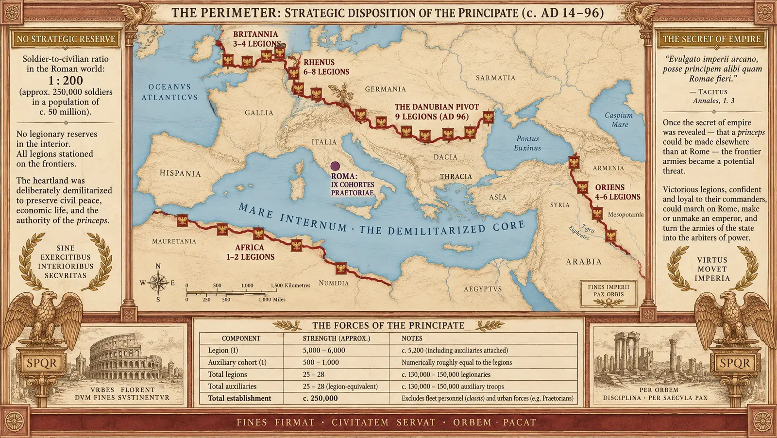
The strategic geometry of the Early Principate: a heavily armed perimeter of three hundred thousand professionals shielding a demilitarized interior, containing no operational reserve save the household guard at Rome.
INFOGRAPHIC BRIEF: VI-G01 — "THE PERIMETER"
1. Purpose and Thesis
To diagram the fundamental strategic revolution of the Principate established between 30 BC and AD 96: the conversion of Rome from an expanding, campaign-based Republic into a garrisoned world-state with a fortified perimeter and a demilitarized, hollow interior. The infographic visualizes the distribution of the standing professional army (~28 legions and auxiliary equivalents) along the outer river, ocean, and desert borders, demonstrating how the entire Mediterranean core was left devoid of field forces. It spotlights the two structural vulnerabilities inherent in the Augustan settlement: (1) the absence of any deep strategic reserve behind the thin frontier ribbon, and (2) the fatal constitutional reality coined by Tacitus (Histories 1.4) in AD 69—that an emperor could be made elsewhere than at Rome.
2. Layout Architecture (Panel-by-Panel)
-
Outer Framing & Title Header (Top):
- Title Cartouche in Gold (
#B89954) against Cream ground (#F4EBD5), framed in Terracotta (#A85638). - Header Text:
THE PERIMETER: STRATEGIC DISPOSITION OF THE PRINCIPATE (c. AD 14–96) - Subtitle:
"The Republic had campaigned; the Principate garrisoned."
- Title Cartouche in Gold (
-
Central Geographic Theater (The Map):
- The Seas & Interior: Pale Aegean blue (
#A4C2D9) for the Mediterranean, Black Sea, and Atlantic; pale sepia landmass for the demilitarized interior provinces (Hispania Baetica, Gallia Narbonensis, Italia, Achaea, Asia, Africa Proconsularis). Labeled across the vacant interior in spaced small capitals:MARE INTERNUM · THE DEMILITARIZED CORE. - The Garrison Ribbon (Outer Edge): Rendered as a distinct, solid Tyrian Crimson (
#8B1A1A) boundary ribbon running along the Rhine, Danube, Syrian Euphrates, Egyptian desert limit, and Numidian fringe. Small square eagle-icons mark legionary stations:- Rhine Sector [8 Legions in AD 14, consolidating to 6 under Flavians]: marked along the lower and upper river.
- Danube Sector [6 Legions rising to 9–10 by AD 96]: labeled
THE DANUBIAN PIVOT · 9 LEGIONS (AD 96). - Britain [4 Legions from AD 43, reducing to 3]: labeled
BRITANNIA · 3–4 LEGIONS. - Euphrates & Cappadocia [4 to 6 Legions facing Parthia]: labeled
ORIENS · 4–6 LEGIONS. - Egypt & North Africa [2 Legions reduced to 1 in Egypt; 1 in Numidia]: labeled
AEGYPTUS & AFRICA · 2–3 LEGIONS. - Hispania [3 Legions reduced to 1]: labeled
HISPANIA · 1 LEGION.
- The Center (Rome):
- A solitary violet-toned crimson node labeled
ROMA: IX COHORTES PRAETORIAE(The sole armed force in Italy: the imperial bodyguard).
- A solitary violet-toned crimson node labeled
- The Seas & Interior: Pale Aegean blue (
-
Flanking Strategic Callouts (Left & Right Flanks):
- Left Callout Box (Doctrine & Vulnerability 1):
- Box Title:
NULLUM SUBSIDIUM: NO STRATEGIC RESERVE - Text:
Between the frontier palisade and the walls of Rome stands no second line. The Principate defends sixty million subjects with roughly three hundred thousand soldiers—a garrison ratio of approximately 1 to 200. If an exterior front is breached, or an army marches inward, the empire contains no operational buffer. The interior peace of two generations is purchased by placing the entire sword upon the edge.
- Box Title:
- Right Callout Box (Constitutional Crisis & Vulnerability 2):
- Box Title:
ARCANUM IMPERII: THE SECRET OF EMPIRE - Text:
"Evulgato imperii arcano, posse principem alibi quam Romae fieri." — Tacitus, Histories 1.4. The standing army is loyal to the emperor as sole patron, paid from his aerarium militare. When dynastic legitimacy fractured in AD 68–69, the four frontier commands discovered that the master of the world was chosen by the legions at the perimeter, not the Senate at the center.
- Box Title:
- Left Callout Box (Doctrine & Vulnerability 1):
-
Bottom Data & Ledger Strip:
- Three structured summary data cells:
- Cell 1 (Total Strength):
25–28 LEGIONS (~160,000 CITIZENS) [AGrade A] + EQUAL AUXILIA (~160,000 NON-CITIZENS) [AGrade A]. - Cell 2 (Garrison Density):
TOTAL FORCE: ~320,000–350,000 MEN · POPULATION: ~60,000,000 · RATIO: ~1:200 [BGrade B order-of-magnitude convention]. - Cell 3 (The Capital):
ITALY GARRISON: 9 PRAETORIAN COHORTS [AGrade A] · ZERO LEGIONS IN RESIDENCE.
- Cell 1 (Total Strength):
- Editorial Grade and Source Tier notation in bottom sub-strip.
- Three structured summary data cells:
3. Palette & Styling
- Background Ground: Antique vellum cream (
#F4EBD5). - Roman Force & Frontier Ribbon: Saturated Tyrian Crimson (
#8B1A1A). - Titling & Embellishment: Roman Imperial Gold (
#B89954). - Cartographic Frame & Rule Lines: Terracotta Red (
#A85638). - Water Bodies: Desaturated Aegean Blue (
#A4C2D9). - Exterior Barbarian Space / Free Germany / Parthia: Iron-Grey wash (
#4A4A4A). - Typography: Lapidary Roman serif capitals for banners; transitional book serif for analytical narrative callouts.
4. Data Values and Attestation Grading
- Legion Establishments: 28 legions (pre-AD 9) down to 25 after the Varian disaster, creeping up under Flavians toward 28–30 (AD 96): AGrade A (military diplomas, garrison epigraphy).
- Auxiliary Parity: Equal establishment of cavalry alae and infantry cohorts: AGrade A (diplomas, discharge records).
- Praetorian Garrison: 9 cohorts in Italy: AGrade A (Tacitus, Suetonius).
- Danubian Strategic Shift: Rhine drawing down from 8 legions; Danube rising from 6 to 9 legions: AGrade A (inscriptions, brick-stamps, diplomas).
- Empire Population (~60,000,000) & Garrison Ratio (~1:200): BGrade B (standard historical order-of-magnitude convention).
- Tacitean Arcanum Formulation: AGrade A (Tacitus, Histories 1.4).
Image prompt (16:9)
A high-resolution strategic infographic in the historical-atlas engraving register, titled 'THE PERIMETER: STRATEGIC DISPOSITION OF THE PRINCIPATE (c. AD 14–96)' on a warm cream ground (#F4EBD5) bordered by an ornate terracotta (#A85638) architectural frame with Roman corner-palmettes. In the center, a detailed map of the Roman Mediterranean world: the seas rendered in pale Aegean blue (#A4C2D9), while the interior landmass (Italy, interior Gaul, southern Spain, Greece, North African coast) is rendered in pale sepia, completely bare of troop icons, labeled across the center in spaced serif lettering: 'MARE INTERNUM · THE DEMILITARIZED CORE'. Along the borders of the empire runs a distinct, bold Tyrian crimson (#8B1A1A) frontier ribbon studded with small square legionary eagle-icons: 'BRITANNIA · 3–4 LEGIONS', the Rhine border with icons labeled 'RHENUS · 6–8 LEGIONS', the Danube river heavily marked with icons labeled 'THE DANUBIAN PIVOT · 9 LEGIONS (AD 96)', the eastern frontier along the Euphrates labeled 'ORIENS · 4–6 LEGIONS', and North Africa labeled 'AFRICA · 1–2 LEGIONS'. In central Italy, Rome is marked by a single distinct purple-crimson node labeled 'ROMA: IX COHORTES PRAETORIAE'. Flanking the map are two formal parchment callout tablets with gold (#B89954) headers: the left tablet titled 'NO STRATEGIC RESERVE' detailing the 1:200 soldier-to-civilian ratio and the complete absence of interior reserve legions; the right tablet titled 'THE SECRET OF EMPIRE' quoting 'Evulgato imperii arcano, posse principem alibi quam Romae fieri' and describing the risk of frontier armies marching on Rome. Across the bottom runs a structured data ledger panel detailing legion strengths, auxiliary parity, and establishment totals. Clean classical serif typography, precise cartographic line work, no modern digital artifacts, elegant antique atlas engraving style.
VI-G01 · generated by the Imperium factory studio (gemini-3.8-flash) from Book VI under the House Preamble.