Book VI · The Wars of the Early Principate
Infographic · VI-G03
JERUSALEM'S RINGS: THE ANATOMY OF A SIEGE (AD 70)
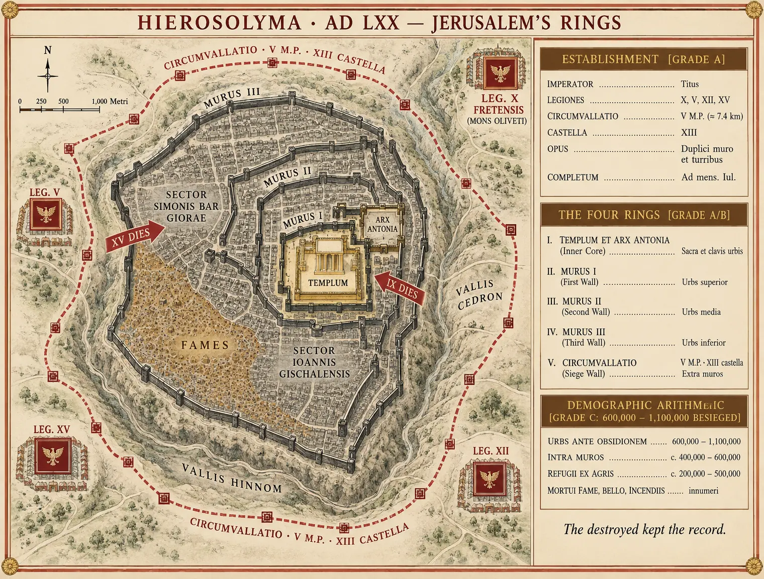
The destroyed kept the record.
DESIGN BRIEF: VI-G03 — JERUSALEM'S RINGS
Purpose
To render the siege of Jerusalem (spring–autumn AD 70) not as a chaotic melee, but as an engineered machine of fatal concentric compression per the thesis of Chapter 6. The infographic illustrates how Titus's four legions systematically constricted the city through four concentric layers: the outer Roman circumvallation line, the breached echelon of exterior walls, the internal famine-and-faction zone, and the sacred Temple core.
Palette & Styling Guidelines
- Series Background: Cream ground (
#F4EBD5). - Border & Frames: Terracotta line-work and decorative corner fillets (
#A85638). - Roman Investment & Breach Trajectories: Tyrian crimson (
#8B1A1A). - Jewish Defenses & Faction Sectors: Iron-grey tones (Slate grey for John of Gischala; Dark iron-grey for Simon bar Giora).
- Famine & Devastation Zone: Punic ochre stipple/hachure (
#B5824A). - Sacred Core & Imperial Cartouches: Gold accents (
#B89954). - Typography: Elegant, high-legibility classical Roman serif (Cinzel / Trajan style for titling; Garamond / Bembo for analytical captions).
Architectural Layout & Text Specifications
+---------------------------------------------------------------------------------------------------+
| [TOP CARTOUCHE in Gold/Terracotta]: HIEROSOLYMA · AD LXX — JERUSALEM'S RINGS                      |
+-------------------------------------------------+-------------------------------------------------+
| LEFT PANEL: CONCENTRIC SIEGE SCHEMATIC          | RIGHT PANEL: METRIC LEDGER & HISTORIOGRAPHY     |
|                                                 |                                                 |
| - RING I (OUTER): ROMAN CIRCUMVALLATION         | PANEL 1: THE FORCES & ESTABLISHMENT             |
|   * Label: "CIRCUMVALLATIO · V M.P. · TRIDUO"    | * Roman Army: 4 Legions + Auxilia (~60,000)     |
|   * 13 Fort redoubts (Castella I–XIII)          |   [AGrade A]
|   * 4 Legion Camps:                             | * Defending Factions: ~25,000 [BGrade B]
|     "LEG. X FRETENSIS (MT. OF OLIVES)"          |                                                 |
|     "LEG. V MACEDONICA"                         | PANEL 2: THE FOUR RINGS (CHRONOLOGY)            |
|     "LEG. XII FULMINATA"                        | * Ring I: 5-Mile Circumvallation [AGrade A]       |
|     "LEG. XV APOLLINARIS"                       | * Ring II: Wall III (15 Days), Wall II (9 Days) |
|                                                 | * Ring III: Granaries Burned; Famine Sovereign  |
| - RING II: THE DEFENSIVE WALLS                  | * Ring IV: Temple Fallen (10 Ab / Aug 70)       |
|   * Label: "WALL III (BREACHED: XV DIES)"       |                                                 |
|   * Label: "WALL II (BREACHED: IX DIES)"        | PANEL 3: THE ARITHMETIC OF CALAMITY             |
|   * Label: "WALL I (OLD NORTH WALL / UPPER)"   | * Trapped Population: 1.1M (Josephus) /         |
|                                                 |   600,000 (Tacitus) [CGrade C: Tradition's Calc] |
| - RING III: FACTION & FAMINE ZONE               | * Captives: 97,000 to Arenas/Mines [BGrade B]    |
|   * Sector: "SIMON BAR GIORA (UPPER CITY)"      | * Material Signature: Ashlar collapse, burnt    |
|   * Sector: "JOHN OF GISCHALA (TEMPLE/ANTONIA)" |   houses, Year 5 shekels [AGrade A]              |
|   * Ochre Stipple: "BURNED GRANARIES & FAMINE"  |                                                 |
|                                                 | PANEL 4: HISTORIOGRAPHICAL NOTE                 |
| - RING IV: THE SANCTUARY CORE                   | "The destroyed kept the record: Flavius         |
|   * Label: "ANTONIA (RAMPS RAISED & MINED)"     | Josephus, Bellum Judaicum. AGrade A eyewitness,  |
|   * Label: "HERODIS TEMPLUM (INCENSUM X AB)"   | audited in the victor's house."                 |
|   * Ravines: "VALLEY OF HINNOM" / "KIDRON"       |                                                 |
+-------------------------------------------------+-------------------------------------------------+
| [BOTTOM FOOTER]: IMPERIUM ROMANUM · BOOK VI · CHAPTER 6: THE JEWISH WAR                           |
+---------------------------------------------------------------------------------------------------+
Exact Verbatim Labels
- Cartouche Title:
HIEROSOLYMA · AD LXX — JERUSALEM'S RINGS - Ring I:
RING I: CIRCUMVALLATIO (V M.P. · XIII CASTELLA · TRIDUO FABRICATA) [GRADE A] - Camps:
CASTRA LEGIONIS X FRETENSIS (MONS OLIVETI),CASTRA LEGIONUM V, XII, XV - Ring II:
RING II: MURUS III (EXPUNCTUS: XV DIES),MURUS II (EXPUNCTUS: IX DIES),MURUS I (MURUS VETUS) - Ring III:
RING III: INTERIOR CONFLICTUS ET FAMES [GRADE A MATERIAL / GRADE C POPULATION] - Faction Leaders:
SECTOR SIMONIS BAR GIORAE,SECTOR IOANNIS GISCHALENSIS - Ring IV:
RING IV: ARX ANTONIA (CAPTUM MENSE PANEMO),TEMPLUM (DIRUTUM ET INCENSUM X AB) - Topographical Valleys:
VALLIS CEDRON,VALLIS HINNOM - Caption Footnote:
The destroyed kept the record.
Image prompt (4:3)
A clean, highly detailed operational military schematic infographic titled 'HIEROSOLYMA · AD LXX — JERUSALEM'S RINGS' in the European historical-atlas register (Putzger style). Cream parchment background (#F4EBD5) enclosed in a double-ruled terracotta frame (#A85638) with gold corner rosettes (#B89954). The left two-thirds depicts an annotated concentric birds-eye tactical plan of Jerusalem in AD 70: the innermost core shows the golden-rendered rectangular TEMPLUM and ARX ANTONIA; surrounded by dark iron-grey defensive circuits labeled 'MURUS I', 'MURUS II', and 'MURUS III'; intersected by crimson assault-breach arrows annotated 'XV DIES' and 'IX DIES'. The city interior is partitioned into iron-grey faction sectors labeled 'SECTOR SIMONIS BAR GIORAE' and 'SECTOR IOANNIS GISCHALENSIS', overlaid with a Punic ochre stippled zone (#B5824A) labeled 'FAMES'. Encircling the entire city outside the ravines of 'VALLIS CEDRON' and 'VALLIS HINNOM' runs the continuous dashed crimson siege-wall labeled 'CIRCUMVALLATIO · V M.P. · XIII CASTELLA' punctuated by 13 small square redoubts, with four Roman legionary camps marked by crimson eagle-squares labeled 'LEG. X FRETENSIS (MONS OLIVETI)', 'LEG. V', 'LEG. XII', and 'LEG. XV'. The right third contains a neat vertical analytical ledger box framed in terracotta with gold serif headings: 'ESTABLISHMENT [GRADE A]', 'THE FOUR RINGS [GRADE A/B]', and 'DEMOGRAPHIC ARITHMETIC [GRADE C: 600,000–1,100,000 BESIEGED]'. At the bottom right, an italicized footnote reads 'The destroyed kept the record.' All lettering rendered in crisp, perfectly legible classical serif typography. No unlisted text, no photographic figures.
VI-G03 · generated by the Imperium factory studio (gemini-3.8-flash) from Book VI under the House Preamble.